When Vegetation Becomes a Threat to Grid Reliability
Vegetation is a major operational risk for transmission and distribution networks worldwide. Tree growth along rights-of-way can compromise minimum safety clearances, while falling trees and branches can damage conductors, disrupt power supply, and, in severe cases, cause outages and infrastructure damage.
The Problem with Looking Only at Today's Conditions
Utilities typically rely on annual line inspections using drones, helicopters, and ground surveys to assess asset conditions and vegetation along the right-of-way. While these inspections provide valuable information about conditions at the time of assessment, they are primarily reactive, as they capture the current state of vegetation rather than predicting future growth and potential risks.
For transmission lines crossing remote areas with dense vegetation and rugged terrain, where operational risks are often higher, inspections become particularly challenging. Limited access can make it difficult for field crews to assess vegetation conditions in detail, while aerial surveys may struggle to identify specific risk points accurately due to obstructed views and surrounding obstacles.
Studies using our clients’ data show that the lack of predictive vegetation monitoring leads to reactive, corrective pruning, with operating costs 3 to 5 times higher than those associated with a predictive pruning approach.
These costs are compounded by potential power outages caused by fires or trees falling onto towers and lines. Such incidents may require emergency crew deployment, infrastructure repairs, and additional measures to restore power supply. Beyond the direct financial impact, they can compromise service continuity and reliability and expose utilities to regulatory penalties.
Vegetation growth also varies by species, location, and environmental conditions, making it difficult to predict where and how quickly risks will develop. Understanding these growth patterns is essential to shifting vegetation management from reactive maintenance to a proactive, risk-based strategy.
Anticipating Risk Before It Reaches the Line
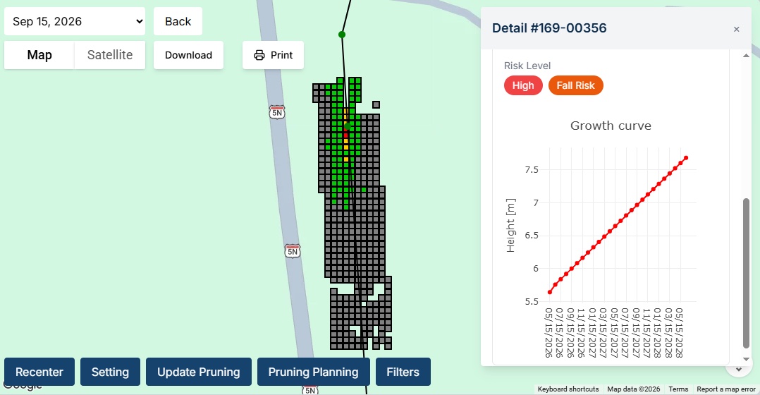
This is precisely what GridSight® VGM is designed to achieve. Using imagery from drones or satellites, combined with point-cloud data, the solution determines tree height and classifies vegetation across the monitored area. It then forecasts growth over the coming months using models tailored to each ecoregion and informed by species taxonomy data.
By projecting future growth, GridSight® VGM estimates when each tree is likely to breach the minimum safety clearance from the nearest conductor, enabling utilities to prioritise interventions based on the timing and level of risk.
From Tree Detection to Predictive Risk Analysis
Each stage of the process is powered by deep learning models trained for specific tasks.
For image segmentation, our Vision Transformer (ViT) computer vision models have achieved an F1 score of 0.95 for tree detection and 0.873 for non-vegetated area detection, performing reliably even in dense forest environments. To estimate vegetation growth, GridSight® VGM uses WWF ecoregion data to identify the ecological characteristics of each project area and apply region-specific growth rates.
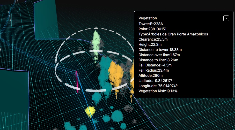
Beyond monitoring safety clearances, the solution also assesses the risk of trees falling onto power lines, identifying locations that require attention before they become critical.
Unlike approaches that assess vegetation risk at span level, GridSight® VGM analyses individual trees, enabling more precise, localised risk assessment and better-targeted maintenance planning.
Turning Vegetation Intelligence into Action
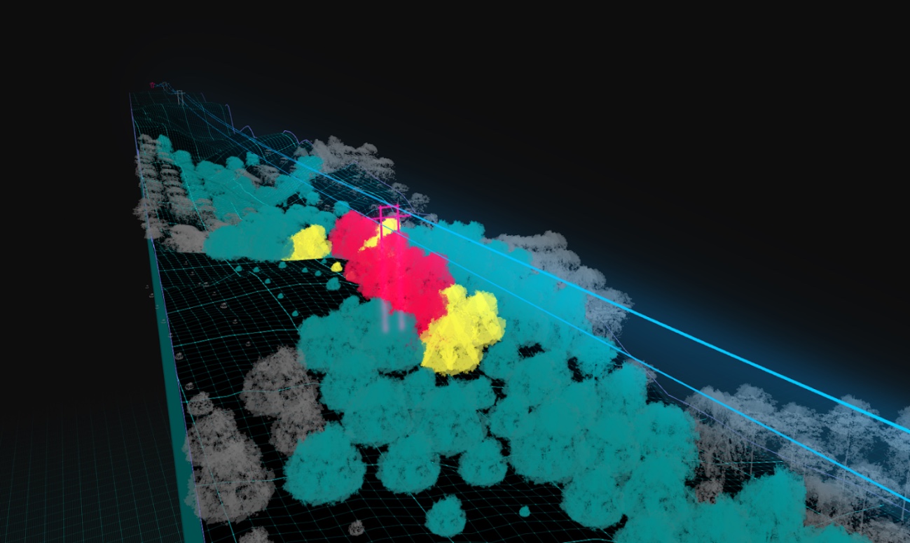
All insights are accessible through the GridSight® VGM platform, which combines risk maps with a 3D digital twin of the line, integrating vegetation cover, towers, conductor catenaries, and terrain elevation.
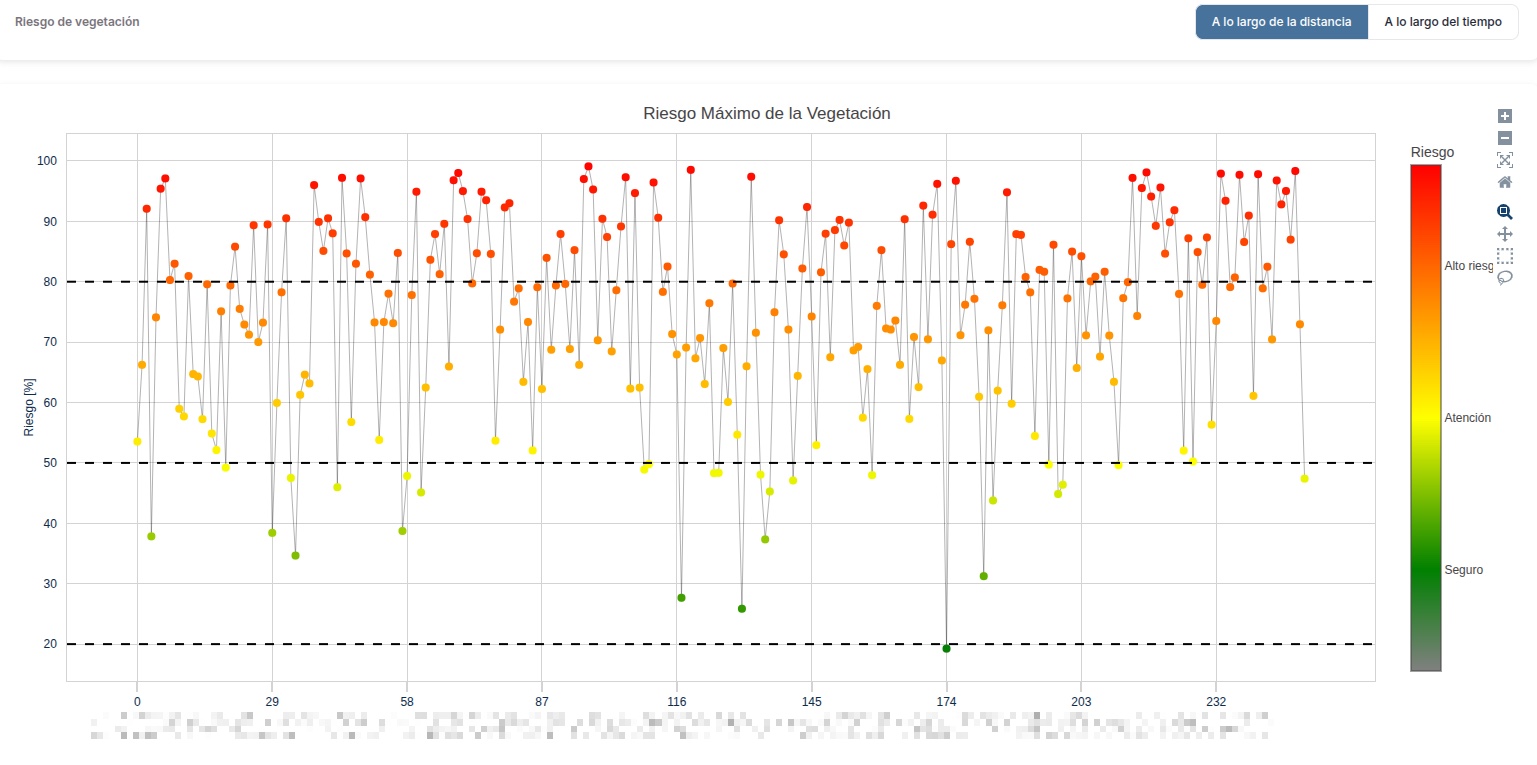
For each monitored location, the platform displays projected vegetation height month by month across the forecast period, alongside conductor clearance, risk levels, and other relevant indicators. This enables utilities to visualise how risks evolve over time and prioritise maintenance accordingly. Data can also be exported to other software, supporting integration into existing analysis workflows and operational planning processes.
GridSight® VGM’s 3D digital twin forecasts vegetation growth month by month against conductor clearance, so utilities can see when risk will appear, not just where. Add the option to export data into existing planning tools, and this becomes a practical decision-making tool rather than just another dashboard.
Keeping Risk Assessments Up to Date
The platform allows utilities to record completed pruning interventions, including the locations, affected line spans, and type of work performed. This information triggers a recalculation of safety-clearance and tree-fall risk levels, keeping the assessment up to date as maintenance progresses.
GridSight® VGM also features a pruning recommendation algorithm that considers risk levels and distances between towers to generate a prioritised list of inspections and interventions. By directing crews to the highest-risk sections first, it helps utilities optimise resource allocation and focus maintenance efforts where they are needed most.
When new imagery or point-cloud data becomes available, GridSight® VGM updates vegetation heights and refines growth forecasts accordingly. It then recalculates projected heights and future risk levels, ensuring assessments reflect the latest available information about conditions along the line.
A Real-World Case: The Cost of Unanticipated Vegetation Risk
A South American utility operating more than 1,000 km of transmission lines across mountainous terrain and densely vegetated areas illustrates the importance of predictive monitoring.
At the time of the incident, the utility had not yet integrated GridSight® VGM into its planning processes. Vegetation management relied primarily on field inspections and aerial surveys conducted a few times a year.
In late 2025, a severe storm caused a tree to fall onto a 33 kV line, interrupting the power supply to more than 1,700 customers. The incident generated over €95,000 in costs associated with emergency response, repairs, and operational rerouting.
Following the incident, as part of the GridSight® VGM implementation process, LiDAR data and historical imagery were analysed to reconstruct vegetation conditions before the event. The analysis revealed that the tree was located in an area of dense vegetation and rugged terrain, where its growth and proximity to the line could have been flagged by GridSight® VGM as a potential risk requiring attention.
Know more: How One Storm Turned Reactive Vegetation Work into Daily Risk Defense.
Conclusions
Vegetation will keep growing, and the pressure on utilities to deliver safe, reliable power will only increase.
The key point here is the gap between inspections. A survey shows today’s picture, but vegetation doesn’t wait for the next one. Combining imagery and point-cloud data with ecoregion-specific growth forecasts lets utilities predict risk instead of reacting to it, which means fewer outages, lower costs, and crews sent where they’re needed most.
GridSight® VGM helps utilities get ahead of these risks.
Would you like to see how GridSight® VGM would work on your own network? Get in touch with us to book a demo.